Tel : 0-2653-8255 , 085-121-2301 | Import and distribute Trimble & Nikon


Hollywood International
ตัวแทนจำหน่าย และศูนย์บริการหลังการขาย ของเครื่องมือสำรวจชั้นนำของโลก ยี่ห้อ Nikon และ Trimble(USA)
We are an exclusive distributor and after-sales service center legally of the world's leading brand in geospatial instruments and technology Trimble (USA) and Nikon.

Hollywood International
ตัวแทนจำหน่าย และศูนย์บริการหลังการขาย ของเครื่องมือสำรวจชั้นนำของโลก ยี่ห้อ Nikon และ Trimble(USA)
We are an exclusive distributor and after-sales service center legally of the world's leading brand in geospatial instruments and technology Trimble (USA) and Nikon.


Core Solutions From GNSS, scanning, and optical technology for field data collection to powerful software programs for processing, modeling, and analyzing captured data.

Trimble software solutions for all applications provides a complete approach to managing field-to-office and bouncing back to the field workflow seamlessly. Trimble enable consistent, standardized data collection to achieve faster time-to-deliverable in the field and expedite field data processing in the office, enabling you to generate quality results with confidence quickly.

Connect and modernize all aspects of the design, construct, operate and maintain phases of the asset lifecycle.
Streamline workflows while getting more value from your asset lifecycles. Trimble empowers you to create transparency, visibility, predictability and more control into your capital program and infrastructure-related projects.

Trimble vehicle-mounted mobile reality capture systems integrate georeferencing technologies with precise, high-speed laser scanning and high-resolution imaging sensors so you can rapidly collect enormous amounts of accurate, georeferenced spatial data and transform it into 3D models, maps, GIS deliverables and more.


A mapping drone for fast and accurate surveying data comes with many features of the most advanced reliability in surveying drones. This is the key to maximizing drone uptime, boosting your productivity and ensuring you deliver consistently.


Hollywood International Ltd.
Survey Department
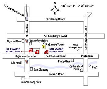
501/4-8 Phetburi Road, Rajtawee, Bangkok 10400
Mobile. : 085-121-2301
Tel. :0-2653-8255, 0-2653-8556 (30 Line)
Fax : 0-2653-9542
Website : www.geohtt.com
E-mail : sv@hollywood.co.th
501/4-8 Phetburi Road, Rajtawee, Bangkok 10400
Mobile. : 085-121-2301
Tel. :0-2653-8255, 0-2653-8556 (30 Line)
Fax : 0-2653-9542
Website : www.geohtt.com
E-mail : sv@hollywood.co.th
Map
Visitor
Copyright © 2023 Hollywood International Ltd. All rights reserved.Design by FINEX DESIGN