Tel : 0-2653-8255 , 085-121-2301 | Import and distribute Trimble & Nikon


WingtraOne Gen II
WingtraOne Gen II comes with a variety of features that make it versatile and efficient:
- Speed
- Increased Area Coverage
- Operational Versatility
- Speed
- Increased Area Coverage
- Operational Versatility
WingtraOne Gen II comes with a variety of features that make it versatile and efficient:
✔ **Speed**:
With WingtraOne Gen II's proprietary technology, it reduces flight time while maintaining high-precision mapping from aerial imagery. Whether it's new field projects or office analysis and processing, WingtraOne Gen II ensures accuracy and efficiency.
**High-Performance Fixed-wing Flight**:
With a flight speed of 16 meters per second (approximately 57 kilometers per hour), WingtraOne Gen II offers high-performance fixed-wing flight, enabling rapid coverage of large areas.
**High-Resolution Camera**:
Equipped with a high-resolution camera of up to 42 megapixels, WingtraOne Gen II surpasses other drones with 20-megapixel cameras, providing superior image quality and larger coverage per flight.
**Reduced Ground Control Points (GCPs) with Checkpoints**:
By utilizing checkpoints instead of GCPs and installing a high-accuracy PPK system with GNSS receivers, WingtraOne Gen II users only need 3-4 checkpoints for high-precision georeferencing, eliminating the need for extensive GCP layouts.
**Maintained Quality with Reduced Overlaps**:
Even with fewer overlaps, WingtraOne Gen II maintains high-quality results. This means each flight covers a larger area, resulting in greater efficiency.
✔ **Increased Area Coverage**:
Whether it's for special highway projects, industrial parks, or mining operations, WingtraOne Gen II efficiently handles large-area projects in just a few hours, compared to other drones that may take much longer.
**Maximum Coverage Area**:
With a ground sampling distance (GSD) of 1.2 centimeters per pixel, WingtraOne Gen II, equipped with an RX1R II camera, can cover an area of approximately 690 hectares at a height of 93 meters.
✔ **Operational Versatility**:
WingtraOne Gen II is designed for vertical take-off and landing (VTOL), allowing it to take off and land virtually anywhere, even in areas with uneven terrain.
These features make WingtraOne Gen II a powerful tool for various applications, providing high-speed, high-precision, and flexible operations for aerial mapping and surveying tasks.
0บทวิจารณ์
-
ยังไม่มีความคิดเห็นสำหรับสินค้าชิ้นนี้
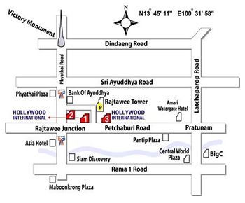
Hollywood International Ltd.
Survey Department
501/4-8 Phetburi Road, Rajtawee, Bangkok 10400
Mobile. : 085-121-2301
Tel. :0-2653-8255, 0-2653-8556 (30 Line)
Fax : 0-2653-9542
Website : www.geohtt.com
E-mail : sv@hollywood.co.th
501/4-8 Phetburi Road, Rajtawee, Bangkok 10400
Mobile. : 085-121-2301
Tel. :0-2653-8255, 0-2653-8556 (30 Line)
Fax : 0-2653-9542
Website : www.geohtt.com
E-mail : sv@hollywood.co.th
Map
Visitor
Copyright © 2023 Hollywood International Ltd. All rights reserved.Design by FINEX DESIGN